Energiewende with a plan: Measuring buoy software for offshore wind farms
How the ISO-Gruppe's software makes a decisive contribution to making modern offshore wind farms more economical and sustainable even before the first sod is turned.
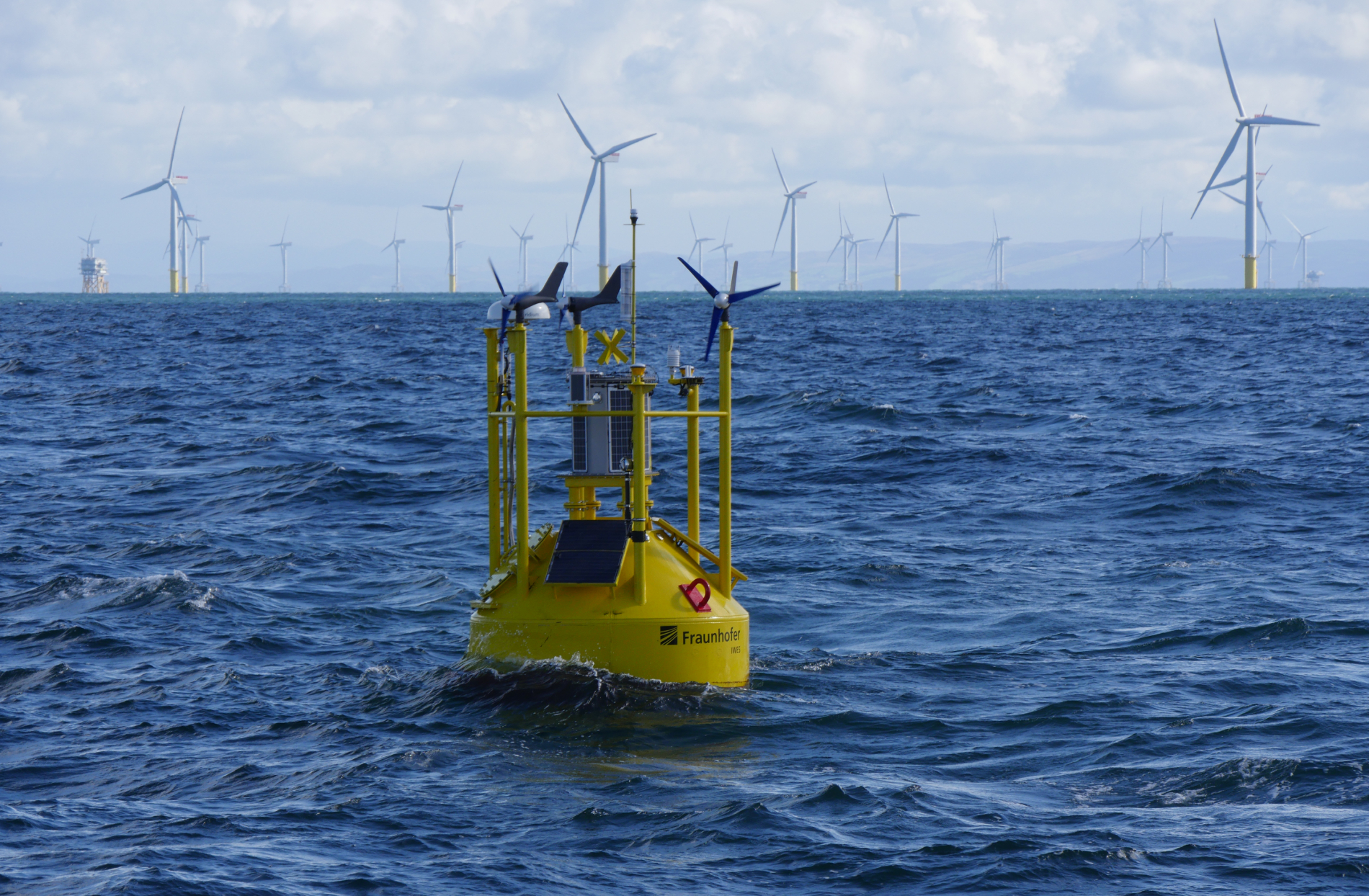
©Fraunhofer IWES_Thomas Viergutz
“The planning of the construction and operation of an offshore wind farm is a highly complex project with a wide range of economic and technological issues,” the Fraunhofer Institute for Wind Energy Systems IWES writes. As a non-expert, you imagine it to be simpler: Put a few wind turbines in the water, pull power cables under the sea and that's it. Above the water, there is no one to disturb – no people, no houses, and hardly any animals. The forces of nature, however, which you want to take advantage of to some extent, are what pose the challenge.
Extreme environmental conditions such as storms, high waves, and strong ocean currents significantly complicate the planning and construction of an offshore wind park. After all, the systems must function reliably over long time so that the high investment sums pay off.
The same is also true for profitability. This is where supposed trivialities already become very noticeable: If individual turbines generate up to 15 megawatts, it is easy to calculate how much electricity up to 50 of them generate in total. In our calculation example, an efficiency that is reduced by only 1% already accounts for 7.5 megawatts. With installation costs of several million euros per megawatt, it is, therefore, worthwhile to determine the economic viability and, of course, the location risks as precisely as possible before starting construction.
High-tech for the high seas: Lidar measuring buoys
For this reason, the Fraunhofer Institute for Wind Energy Systems, or IWES for short, has developed a technical jewel suitable for the high seas: A measuring buoy equipped with the Lidar sensor (light detection and ranging) measures wind directions, wind strengths, currents, temperatures and much more. The motion sensors are particularly important because they provide data for matching with the lidar readings to factor out the inevitable movements of the buoys. Great care is taken to ensure that the buoy measurements are accurate and correspond to the stationary reference measuring poles. The data from the FINO reference masts, of which there are three, serve as the basis for the certification of the buoys.
This way, important and comprehensive data can be collected before construction begins to ensure that the targeted sea area is suitable for an offshore wind farm in the long run. Measuring buoys are an effective tool, especially for long-term analysis, as they are firmly anchored to the seafloor and relentlessly collect data 24 hours a day, 7 days a week. A self-sufficient energy supply in the buoy renders this possible. The extensive measurement data is recorded and collected during maintenance visits. Small data pre-evaluations, on the other hand, are transmitted by the buoy via satellite.
Measuring buoy software – what is the ISO-Gruppe's role?
In the age of digitalization, it is impossible to imagine a product without sophisticated IT. Thus, software technologies such as Scala, Akka, Git, and common products in the scientific community such as TeX including Gnuplot are used.
It was precisely this complex technology stack that presented Fraunhofer IWES with a challenge. Which IT service provider masters such an extensive range? ISO Software Systeme GmbH is one of the few IT companies that have mastered all these disciplines. ISO Software Systeme gladly accepted the task and together with IWES started to further develop the software for the measuring buoys.
Individual Software: Three phases to success
The project entered phase 1 on 01 January 2021. The focus was on optimizing existing Fraunhofer software, documenting the new program parts, and setting up a CI (Continuous Integration) environment. The project progressed quickly because the collaboration with the Fraunhofer Institute was very good and our developers already had extensive experience with the technology stack. Phase 2 began as early as May 2021 with the further development of the software.
The central point was the development of the QM module for use on the buoy itself. The main program or correction software, which analyzes and processes the collected measurement data, on the other hand, runs on dry land. The QM module has the task of aggregating measurement data in advance and monitoring various vital signs. These relatively small amounts of data are transmitted daily and processed graphically, which is also a feature of the QM module.
This provides a rough overview of the ongoing measurements and the health of the buoy. This makes it possible to detect problems in good time, for example, if a sensor fails or the buoy breaks away from the anchor and starts wandering. Or when a seagull has left something on the lidar optics and the windshield wiper fails. In addition, from time to time there were new sensors or new data formats to which we needed to adjust the software.
Furthermore, we have introduced software protection via a dongle to prevent cyberattacks. To achieve this, the part of the QM module that works directly on the buoy had to run on a low-power computer. The energy on the buoy is precious and so the power consumption was not allowed to exceed 5 watts.
Measuring buoy software: from project to commercial operation
The Fraunhofer Institute was very satisfied with the results and commissioned phase 3 as the conclusion of the project in September 2021: ongoing support including bug fixing and even further developments if required. The project has long since transitioned into commercial operation.
The measuring buoys have already been in use with customers in the Scottish North Sea, east of Aberdeen/Edinburgh, since 2017. In 2020, further buoy measurements followed over twelv-months for the Deutsche Bundesamt für Seeschifffahrt und Hydrografie (the German Federal Maritime and Hydrographic Agency). The measurements take place on the occasion of the preliminary site investigation for offshore wind development in the German bay. The buoys also diligently collect data for research projects in the North Sea and the Irish Sea.
The ISO-Gruppe supports the Energiewende
Renewable energies play a decisive role for industrial nations – not in the distant future, but now. This has been demonstrated not only by the increasingly noticeable climate change but also by political crises and conflicts. Offshore wind farms play a key role in making us as independent as possible from fossil fuels. Especially in the fall, winter, and spring, when sunshine hours are sparser and even large PV systems lose massive power, wind power is needed to keep the wheels turning on roads and in businesses. We are therefore very proud that ISO Software Systeme GmbH is making a small but important contribution to the success of the Energiewende.
Learn more about the lidar measuring buoys on the website of the Fraunhofer Institute for Wind Energy Systems. If you would like to see it for yourself, the Fraunhofer Institute has produced a highly interesting video on the project which introduces the people and machines involved.
Sources
Fraunhofer IWES: Lidar Buoy for flexible site Assessment
Fraunhofer IWES: Wind energy buoy brochure
Fraunhofer IWES: Wind energy Video
